A trip to photograph the universities in Superior, WI and Duluth, MN had been on the back burner for some time. Because the weather forecast was exceptional and we were at Killasonna, which is a shorter drive than it is from Evanston, we packed up and started driving toward Rhinelander on Halloween day, October 31, 2022.

We opted to take the roads less traveled, as Carolyn had never been through the North Woods of Wisconsin before.

As we wound our way toward Rhinelander along a river in the Menominee Indian Reservation, we immediately noticed that the area is largely unspoiled. Gone were the roadside stores and even farms; replaced by quiet forests and a river. It seemed familiar and I guessed it might be the Wolf River, where I had canoed with Ray some thirty plus years ago. The same Wolf River where we wrapped our canoe around a mid-stream boulder … but that’s another story. We pulled over were the road allowed us to access the river and took in the magnificence.


In the mid-1970’s my ex-wife and I, along with some friends, stayed at a cabin at a resort called Holiday Acres, on Thompson Lake, several miles East of Rhinelander. Our friends had stayed at this particular cabin in the past and claimed that it was haunted. Uh huh. Well it turned out that is was indeed haunted … but that too is another story. Holiday Acres is a quintessential Northwoods resorts with a couple dozen cabins and a lodge (for people who don’t tolerate spiders) with a supper club-like bar and dining room. It was renowned, “back in the day,” for offering great jazz in the dining room. And by that, I mean the likes of Woody Herman, the Count Basie Orchestra, the Duke Ellington Band, and such. Since we were passing nearby, I wanted to see if it bore any resemblance to my fading memory and to show Carolyn the place that I had described to her a number of times.

Memory is a funny thing. Holiday Acres, which celebrated it 70th anniversary in 2019, was very much like I remembered it and yet different. For example, I only vaguely remembered the hexagon-shaped bar.

Despite my questionable memory, I recognized the cabin. When I was last there, in the 1970’s, the cabins came with a boat and firewood. I remember fishing there, but I don’t remember if I caught anything.


Our next stop was Copper Falls State Park, arguably the most scenic of Wisconsin’s state parks. And it lived up to that claim. The photo above is of the Bad River, which is what feeds the falls.

Unfortunately, Copper Falls, in the photo above, is suffering from a lack of water. This is, I imagine, driven by the fact that it’s Fall and the ongoing drought. Presumably, it will be roaring in Spring.

Brownstone Falls, a short walk upstream from Copper Falls, is fed by the Tyler Forks River.

Before long, we finally reached Ashland, where we had a reservation at The Hotel Chequamegon. Our room provided a beautiful vista of Lake Superior. We ordered take-out onion pizza from Frankies Pizza. It was quite tasty. Chicago style; thin crust and cut into squares. At breakfast, the hotel had the sense to offer salsa with the scrambled eggs, which made such a difference, as we avoided the sausage. We were also pleased to find that the plates and silverware were not plastic. Ashland was relatively quiet, despite it being Halloween. It has a downtown of several blocks, with a variety of older, preserved buildings. One mural that caught our eye was that of an “ore dock;” an imposing structure, unlike anything we had ever seen before.
The next morning we searched for the ore dock, but it looked to be nothing more than a long pier. Afterwards, as we headed to Superior, we stopped at the Northern Great Lakes Visitor Center on Hwy 2, just West of Ashland. It’s a huge center that looked fascinating, but we needed to move on to Superior because we had a college to shoot.
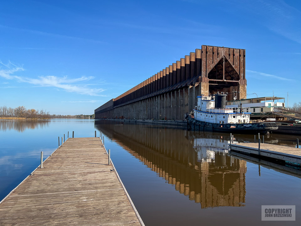
As we arrived in Ashland, we passed under covered bridge. Not just an ordinary covered bridge, like the quaint bridges found in rural Indiana and elsewhere. This was a trestle bridge that stood high above the street and extended in either direction as far as we could see. “What the heck was that?” A bit further down the road we spotted this enormous structure, which looked exactly like the “ore dock” mural in Ashland. I did a quick U-turn so we could take a closer look. I took some photos, like this one, but this side of the structure was in shadow and I wanted to take a shot of the sunny side. Having noticed a woman and a dog in the adjacent marina, we walked over.

We soon met Lisa, who, along with her husband own the Loon’s Foot Marina, as well as the ore dock structure (!), which I would guess to be over 1,000 feet long and three stories tall. “What is that?” we asked. Lisa explained that it’s an old “ore dock,” out of use since 1959. It was originally known as the Northern Pacific Ore Dock No. 1. She described how iron ore was once delivered from Minnesota and loaded here on to freighters. The curious, covered trestle bridge down the road remains operational and connected to a still functioning ore dock. At one time a similar trestle and set of train tracks was attached to this ore dock. She and her husband bought the property about 15 years ago and opened the marina.
Lisa suggested walking down the footpath to the East of the marina, to see the operational oar dock to which the trestle bridge that we saw when driving into town is connected, but we were short on time.

As we were leaving the marina, Carolyn suddenly stopped and pointed at one of the boats, “Look! A Plimsoll Line.” This was a term that we just learned a few days earlier. The Plimsoll line is a reference mark located on a ship’s hull that indicates the maximum depth to which the vessel may be safely immersed when loaded with cargo.


This is The Aerial Lift Bridge, earlier known as the Aerial Bridge or Aerial Ferry Bridge, which is a landmark of Duluth, Minnesota. It was built in 1905 as the United States’ first transporter bridge. Only one other was ever constructed in the country was known as the Sky Ride, built for the 1933 Century of Progress World’s Fair in Chicago. Unfortunately, the Chicago bridge was dismantled after the Fair.
We spent a few hours exploring Duluth and had lunch downtown. We had no particular expectations of Duluth, but the extent to which Duluth is an industrial city surprised us. It was telling to find that the downtown buildings are interconnected with enclosed bridges, much like Minneapolis.
Having some time on our hands, we headed to Minnesota Point, the sliver of land that separates Lake Superior from the Bay. We drove as far as the small airport and admired the views, before deciding to return to Superior, as I wanted to photograph Lisa’s ore dock basking in the afternoon sunlight. I was not disappointed. Afterwards we walked the footpath to see the operational ore dock.


The following day, after finishing up shooting UM-Duluth and University of St. Scholastica, we headed out of town. In Superior, we again encountered the curious covered bridge that spanned over the road. It extends from the ore dock to a huge industrial property that is at least a mile in length and a third of a mile in width. We discovered that this structure houses a conveyor to transport the ore between the dock and the plant.
We followed the enclosed structure, to see where the ore was headed. The conveyor extended about a mile and we encountered piles of finely crushed ore, which is actually “taconite,” a low-grade iron ore composed of 20–30 percent magnetite. Once upon a time, when high-grade natural iron ore was plentiful, taconite was considered a waste rock. But as the supply of high-grade natural ore decreased, taconite became a resource. Similar to oil, its peak abundance is now history.

Above, mountains of taconite.
Afterwards, we decided to drive straight back to Door County. Fortunately, podcasts kept us occupied and the 6 hour trip went by smoothly. Within an hour of arriving, we had a blazing fire going and settled back with a couple glasses of wine to review our trip.